Dynmap: Difference between revisions
No edit summary |
|||
| Line 7: | Line 7: | ||
== Criticism == | == Criticism == | ||
The [[First Survivor]] was strongly opposed to releasing the mapping data to the public for privacy reasons, noting that it would be nearly impossible to hide builds and other activity in the [[Web Worlds]] if all the mapping was immediately made public. Also, the thrill of discovery could be diminished, as you would always know what was over the next hill and in the next valley with a simple click of the mouse. | The [[First Survivor]] was strongly opposed to releasing the mapping data to the public for privacy reasons, noting that it would be nearly impossible to hide builds and other activity in the [[Web Worlds]] if all the mapping was immediately made public. Also, the thrill of discovery could be diminished, as you would always know what was over the next hill and in the next valley with a simple click of the mouse. He pleaded for incremental compromises, such as only rendering the Dynmap out to a certain distance, or delaying the update to weekly or even monthly. | ||
After contentious debate, [[LEIGH&CO]] eventually caved to public pressure and released the mapping product after a campaign by [[xtonx723]] and [[mrunix]], both of whom vocally claimed that despite all the other navigation aids provided, despite the constant availability of GPS coordinates, and despite the fact [[New Eden City]] was at the easy-to-remember coordinates of 0,0, they would get hopelessly lost. | After contentious debate, [[LEIGH&CO]] eventually caved to public pressure and released the mapping product after a campaign by [[xtonx723]] and [[mrunix]], both of whom vocally claimed that despite all the other navigation aids provided, despite the constant availability of GPS coordinates, and despite the fact [[New Eden City]] was at the easy-to-remember coordinates of 0,0, they would get hopelessly lost. | ||
Revision as of 01:14, 30 August 2021

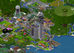
Dynmap is an geospatial mapping product provided for the benefit of all Colonists by LEIGH&CO. The data is gathered by on-orbit satellites and updated in near realtime, nominally, 10-20 seconds. Datum overlays are provided for such useful features as the current world Radiation Border, as well as Land Office lots. Additionally, Colonist tracking data from their LeighBoy personal data devices are updated in realtime on the map, ensuring that nobody can hide. Anywhere.
Each Dynmap represents a single planet, and any dimensions that may be included in that planet, such as The Nether and The End. The Dynmap offers both 2D and 3D views, as well as an X-Ray view allowing the user to see underground. To change your view, activate the flyout by hovering along the right edge of the screen.
Criticism
The First Survivor was strongly opposed to releasing the mapping data to the public for privacy reasons, noting that it would be nearly impossible to hide builds and other activity in the Web Worlds if all the mapping was immediately made public. Also, the thrill of discovery could be diminished, as you would always know what was over the next hill and in the next valley with a simple click of the mouse. He pleaded for incremental compromises, such as only rendering the Dynmap out to a certain distance, or delaying the update to weekly or even monthly.
After contentious debate, LEIGH&CO eventually caved to public pressure and released the mapping product after a campaign by xtonx723 and mrunix, both of whom vocally claimed that despite all the other navigation aids provided, despite the constant availability of GPS coordinates, and despite the fact New Eden City was at the easy-to-remember coordinates of 0,0, they would get hopelessly lost.
This would later come back to haunt mrunix when he bitterly observed that everyone followed him around the server, since his builds and location were readily available on the map. To this, spokesperson Miguel Vector went on record as saying "We all told you so".
Maps
- New Eden Planet
- The Moon (VPN Only)
- The Dream (VPN Only)