ASUKA: Difference between revisions
Jump to navigation
Jump to search
No edit summary |
|||
| (19 intermediate revisions by the same user not shown) | |||
| Line 1: | Line 1: | ||
[[category:Technica]] | |||
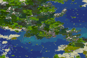
[[file:Asuka1Data.png|right|thumb|Bloc 1 Product]] | |||
The [[LEIGH&CO]] ASUKA programme is a series of geotechnica satellites and related launch facilities, data processing, and other activities. | The [[LEIGH&CO]] ASUKA programme is a series of geotechnica satellites and related launch facilities, data processing, and other activities. | ||
* ASUKA-1 The initial launch for the ASUKA program. Produced 1 meter resolution color data in the visual spectrum as well as LIDAR data an isometric angle out of the southeast, out to 10km from [[New Eden City]]. | * ASUKA-1 The initial launch for the ASUKA program. Produced 1 meter resolution color data in the visual spectrum as well as LIDAR data an isometric angle out of the southeast, out to 10km from [[New Eden City]]. | ||
* ASUKA-2 Second ASUKA launch completed a survey of [[New Eden]] in Y2S3, producing 1-meter color visual and composite LIDAR data from an isometric angle out of the southeast, out to 20km from [[New Eden City]]. Data processing for this product is ongoing, and made available to end-users via the [[Dynmap]] service. | * ASUKA-2 Second ASUKA launch completed a survey of [[New Eden]] in Y2S3, producing 1-meter color visual and composite LIDAR data from an isometric angle out of the southeast, out to 20km from [[New Eden City]]. Data processing for this product is ongoing, and made available to end-users via the [[Dynmap]] service. | ||
* ASUKA-3 A third ASUKA launch | * ASUKA-3 A third ASUKA launch provides a 1m multispectral sensing capability from a direct overhead angle. This data will be processed to produce a forest canopy, hydrological, climatological, and magma survey. | ||
== ASUKA-3 == | == ASUKA-3 == | ||
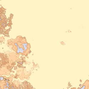
[[file:AsukaRawData.png|right|thumb]] | [[file:AsukaRawData.png|right|thumb||Bloc 2 Raw Product]] | ||
ASUKA-3 is a follow-on to the ASUKA-1 and ASUKA-2 missions While 1 | Launched in Y2S3, ASUKA-3 is a technical follow-on to the ASUKA-1 and ASUKA-2 missions. While Bloc 1 satellites focused on producing high resolution visual imaging, the ASUKA-3 mission collects additional scientific data. The Bloc 2 satellites are capable of capturing the following datastreams at 1 meter resolution: | ||
* LIDAR Altitude (Y-value) | * LIDAR Altitude (Y-value) | ||
* Ground-Penetrating Radar Altitude | |||
* Visual Imaging | * Visual Imaging | ||
* Temperature | * Infrared Sensing (Temperature) | ||
* Humidity | * Humidity | ||
* Biome | * Biome Composition | ||
* Landform | * Landform Classification | ||
* Surface Albedo | |||
Raw mission telemetry is then processed into | Raw mission telemetry is then processed into GeoTIFF format where it then can be processed by existing tools, such as GDAL, ArcGIS, QGIS, etc. The total uncompressed product is ~1TB. Time on orbit to produce a single global survey is 7.011 days. | ||
Latest revision as of 17:25, 7 September 2021

The LEIGH&CO ASUKA programme is a series of geotechnica satellites and related launch facilities, data processing, and other activities.
- ASUKA-1 The initial launch for the ASUKA program. Produced 1 meter resolution color data in the visual spectrum as well as LIDAR data an isometric angle out of the southeast, out to 10km from New Eden City.
- ASUKA-2 Second ASUKA launch completed a survey of New Eden in Y2S3, producing 1-meter color visual and composite LIDAR data from an isometric angle out of the southeast, out to 20km from New Eden City. Data processing for this product is ongoing, and made available to end-users via the Dynmap service.
- ASUKA-3 A third ASUKA launch provides a 1m multispectral sensing capability from a direct overhead angle. This data will be processed to produce a forest canopy, hydrological, climatological, and magma survey.
ASUKA-3

Launched in Y2S3, ASUKA-3 is a technical follow-on to the ASUKA-1 and ASUKA-2 missions. While Bloc 1 satellites focused on producing high resolution visual imaging, the ASUKA-3 mission collects additional scientific data. The Bloc 2 satellites are capable of capturing the following datastreams at 1 meter resolution:
- LIDAR Altitude (Y-value)
- Ground-Penetrating Radar Altitude
- Visual Imaging
- Infrared Sensing (Temperature)
- Humidity
- Biome Composition
- Landform Classification
- Surface Albedo
Raw mission telemetry is then processed into GeoTIFF format where it then can be processed by existing tools, such as GDAL, ArcGIS, QGIS, etc. The total uncompressed product is ~1TB. Time on orbit to produce a single global survey is 7.011 days.